Sampson Park is a nearly 200 acre preserve in Kingston along the Jones River. There are three certified vernal pools in the park. During hunting season, walkers and dogs should wear blaze orange to stay safe. The town started to acquire this parcel of land in 1950 with 52 acres. In 1963, the town added nearly 100 acres in honor of Elizabeth Sampson. The Bay Circuit Trail runs through Sampson Park. LOCATION: Elm Street Kingston, MA STROLLER SCORE: TBD LINKS: Trail Map Wicked Local Article [2010]
The Silver Lake Sanctuary consists of 100 acres of land along the shores of Silver Lake. The property provides the only public access to Silver Lake in the town of Kingston. The lake is a 640 acre pond. Silver Lake is used as a water source for the City of Brockton. (Source: Kingston Conservation Map) LOCATION: Access via Pembroke St (Route 27) Kingston, MA STROLLER SCORE: TBD LINKS: Trail Map Wicked Local Article [2010]
This 24 acre property consists of a rolling pasture and wooded upland next. Located next to Smelt Brook and Foundry Pond in Kingston. This site was once a former working dairy farm. (Source: Kingston Conservation Map) LOCATION: Baslers Lane Kingston, MA STROLLER SCORE: TBD LINKS: Trail Map
This 225 acre property abuts the Jones River and has three brooks that travel through it: Howards Brook, Pine Brook, and one unnamed brook. This large property area contributes greatly to the Jones River Watershed. A portion of the Bay Circuit Trail runs through the property as well. LOCATION: Access from Rt 27 parking behind Silver Lake Middle School STROLLER SCORE: TBD LINKS: Trail Map AllTrails Information Wicked Local Article [2010]
Trail Listing Trail Reviews Town Landscape Conservation History More Info! TRAIL LISTING We've combed the internet and maps to pull this list together. Don't see your favorite? Tell us via the live chat. Town Town Site Website Table List Acres Dogs Stroller? Water? Agency Abington Abington Ames Nowell State Park Ames Nowell State Park 700 y pond State Park Abington Abington Island Grove Park Island Grove Park 53 pond Town Abington Abington Griffin Dairy Farm Griffin Dairy Farm Abington Abington Beaver Brook Playground Beaver Brook Playground Braintree Braintree Braintree Town Forest Braintree Town Forest 85 wetlands Town Braintree Braintree Cranberry Pond Cranberry Pond 140 pond Town Braintree Braintree Eaton's Pond Area Chapman's Landing & Iron Mine Brook Trails 28 Y river Town Hanover Hanover Clark's Bog Trail Loop French's Stream...
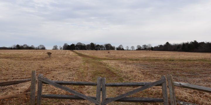
The Bay Farm trail is an 80 acre land preserve located in Duxbury along the Kingston Bay. The acerage is comprised of land owned by Kingston, Duxbury, and the state. Upon first arriving at the trail, visitors are immediately drawn to the large open space that feels reminiscent of Turkey Hill or World's End. The simple Bay Farm trail network provides incredible views of Kingston Bay, the Myles Standish Monument, Clark’s Island, Gurnet Light, Rocky Nook and Saquish. The property has become a popular location in all seasons with dog-walkers, bird watching, fishing, and even cross-country skiing. HISTORY Duxbury acquired after the original onsite farm first in 1973. Although originally a dairy farm for the first half of the 20th century, a group of actors purchased the land and formed the Duxbury...