Misty Meadows is a 153 acre parcel of land in Pembroke. The trail network abuts the Willowbrook Preserve maintained by the Wildlands Trust. The trail network is definitely not the most travelled in the area and can be a bit concealed. LOCATION: Pembroke, MA STROLLER SCORE: TBD LINKS: Trail Map
Shepherd's Forest Trails is a 139 acre parcel of land in Pembroke. The nested trail network is sandwiched between Great Sandy Bottom Pond and Indian Head Pond. LOCATION: 3 parking locations available off Mattakeesett Rd & Marquan St Pembroke, MA STROLLER SCORE: TBD LINKS: Trail Map
Sampson Park is a nearly 200 acre preserve in Kingston along the Jones River. There are three certified vernal pools in the park. During hunting season, walkers and dogs should wear blaze orange to stay safe. The town started to acquire this parcel of land in 1950 with 52 acres. In 1963, the town added nearly 100 acres in honor of Elizabeth Sampson. The Bay Circuit Trail runs through Sampson Park. LOCATION: Elm Street Kingston, MA STROLLER SCORE: TBD LINKS: Trail Map Wicked Local Article [2010]
The Silver Lake Sanctuary consists of 100 acres of land along the shores of Silver Lake. The property provides the only public access to Silver Lake in the town of Kingston. The lake is a 640 acre pond. Silver Lake is used as a water source for the City of Brockton. (Source: Kingston Conservation Map) LOCATION: Access via Pembroke St (Route 27) Kingston, MA STROLLER SCORE: TBD LINKS: Trail Map Wicked Local Article [2010]
This 24 acre property consists of a rolling pasture and wooded upland next. Located next to Smelt Brook and Foundry Pond in Kingston. This site was once a former working dairy farm. (Source: Kingston Conservation Map) LOCATION: Baslers Lane Kingston, MA STROLLER SCORE: TBD LINKS: Trail Map
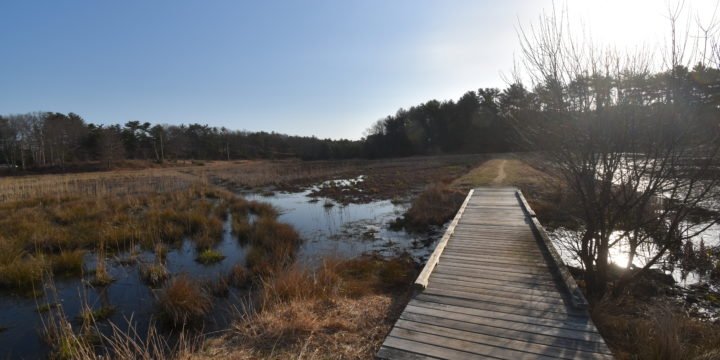
This 225 acre property abuts the Jones River and has three brooks that travel through it: Howards Brook, Pine Brook, and one unnamed brook. This large property area contributes greatly to the Jones River Watershed. A portion of the Bay Circuit Trail runs through the property as well. LOCATION: Access from Rt 27 parking behind Silver Lake Middle School STROLLER SCORE: TBD LINKS: Trail Map AllTrails Information Wicked Local Article [2010]
Luddam's Ford Park is a trail located off Water Street in Hanover. It is connected to the Indian Head Trail. The combination of the two trail systems can be around 4 miles of hiking; however, if you stick with just Luddam's Ford Park you can have a very manageable hike. The Luddam's Ford Park trails are centered around the pond. There are several trails that nest together but the two main trails are called out by Red and Green markers. In addition, there is a boat launch for kayaks and other non-motorized watercraft. At the base of the pond is a dam that is a particularly enjoyable sight after significant rainfall. In addition to the dam, there is a herring run that is monitored by the North South River Watershed...
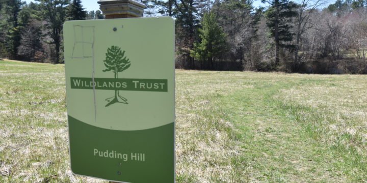
Pudding Hill Reservation is located off Rt 123 in Pembroke near Marshfield Center. The site consists of two main pieces: field leading to a pond and short wooded trails. The primary trail entrance is located just at the base of the pine tree covered hillside across from the pond. The Pudding Hill reservation is managed by the Wildlands Trust. Here are some additional ecological notes from the Wildlands Trust: White pines dominate on the gravelly soils of this glacial ridge and create an open, airy forest. In spring, a high-pitched, trilling song may alert you to the presence of a nesting pine warbler or chipping sparrow. White oaks and black oaks are found in some parts of the preserve. The South River is little more than a brook here and...
Tidmarsh Sanctuary is a 481-plus acre landscape in Plymouth. Once a working cranberry farm, this landscape underwent the largest freshwater ecological restoration ever completed in the Northeast. Its previous owners, the Schulman Family, along with the Massachusetts Division of Ecological Restoration, U.S. Department of Agriculture’s Natural Resources Conservation Service, and many other organizations, re-created nearly three and a half miles of meandering stream channel, sculpted the land’s surface, and removed nine dams to reconnect the headwaters of Beaver Dam Brook to the ocean for the first time in more than a century. The restoration before and after images are absolutely worth checking out! As a result of the collective actions of the collaborators, this entire landscape is now on a dramatic trajectory of change—a spectacle that will play out for...
Crowell Conservation area is located on Lincoln Street in Duxbury. The area is made up of primarily historic cranberry bogs and nearby ponds. The cranberry bogs were operating for 100 years and retired in 2010! Depending on the time of your visit, the paths may be a bit wet - however given the elevated nature of the bogs, you won't get too muddy. The bogs attract some incredible birding opportunities so be sure to bring your binoculars . This is a dog friendly site but be sure to keep your dog on a leash and pick up any waste. Duxbury has provided a trash can at the entrance of the trail to dispose of dog waste. TRAIL NOTES: trails are primarily around the perimeter of cranberry bogs excellent for birding!...